This is the 2nd part of my blog Bogota To Buenos Aires, if you want to go back to the first part
Go back to the first part Bogota to Pisco
Day 38 – July 13 – Pisco to Ayacucho – 340km
I woke up early after having not slept so well and was on my way at 0730 with today’s goal being Ayacucho up in the mountains. I didn’t know what to expect and the first 100km or so was in a deep valley going gently higher but as I reached the end of the valley it started to go up higher – much higher. When the temperature reached 5C with strong winds I stopped to put my hotwired jacket and thicker gloves on. As I kept climbing higher the temperature got colder and colder and finally reached 2C – boy, was I glad I had that jacket as well as the heated grips and when finally reaching the top of the pass it was at 4764m! That’s almost as high as Mont Blanc… It was snowing a bit and the surroundings were white. Brrr…

Top of the pass at 4746m

Looks cold and inhospitable, no?

Llamas – first of these I’ve seen

Oh yes – snow! Luckily not on the road.

Ayacucho. Local ladies enjoying an afternoon break looking at the kids practicing local moves.

Kids practicing local traditional dancing?
I made it down to lower levels and higher temperatures and found the hostel in Ayacucho without too much problem. I should be able to make Cusco in a couple of days from here and take a few days there to go to Machu Picho…
After dinner I walked around town for a while and I found the town to be quite prosperous with a large pedestrian precinct and a really big square.

Beautifully lit main square.

Pedestrian area at 2130. Still lots of people about.

Day 39 – July 14 – Ayacucho to Andahuyalas – 220km
I slept really badly – it felt like I never got to sleep. I thought I was used to the high altitude but maybe spending four nights at sea level undid all those nights I did spend close to 2500m?

Stopped for a delicious lunch by the road side.
The goal for today was Abancay but at 1400 that was a further three hours away so I decided to stop in this town, Andahuyalas . It’s not a very nice looking town built on the side of a valley with steeply sloping streets and everything is pretty dusty. When you’ve seen a few towns in Peru you realize they don’t care much what the houses look like from the outside, it’s usually a structure of concrete beams filled in with bricks, and it’s left like that. No attempt to beautify…

The roads today came up to more than 4000m on two stretches and then down to the valleys at around 2000m so a lot of switchbacks and lovely roads for riding a motorcycle. For the first 80kms Maps.me led me on a very small road with a fair amount of traffic so very slow going. I checked Maps.me on my mobile phone and that must be a different version because that showed I should have gone on the proper bigger road, PE-3S. maps.me has led me astray few times on this trip so I think I will switch to the ‘HERE’ navigation app.
Day 40 – July 15 – Andahuyalas to Ollantaytambo – 360km
I haven’t dropped a bike for some time but today it happened! Yesterday when I put the bike in secured parking I had to go down some steps with some gravel at the last step and I knew it was going to be difficult to get up the steps today. So when riding up the steps the rear wheel started spinning and the bike stopped and I couldn’t hold it up so down it went. Luckily the protective bars hit the ground and the only damage was the front wheel brake lever which broke where it’s designed to break, right at the tip. So no real problem, only to my pride:-(
After that I got going but, again, took some time to get out of the town. The towns in Peru have no signs telling you how to find the route so I rely completely on the GPS which again screwed me up… There was Sunday market so I could not go where the GPS told me to go and after that it led me on some small steep gravel roads so after a while I switched back to Google maps which safely led me out of town.
Today was a long stretch with 3 or 4 mountain passes with amazing views and so many switchbacks I almost got dizzy. The last stretch Maps.me led me down a small dirt road that was being constructed which was a real challenge to navigate.

The road climbed 2000m above Abencay and you could see all the way down. Beautiful!

Amazing snow covered mountains mixing with the clouds.
In Ollantaytambo the street leading into the town is surfaced with really large cobblestones which are very difficult to navigate at slow speed with a heavy bike. So when I had to stop for oncoming traffic and started to get going the front wheel caught behind a big cobblestone and the bike stalled and I dropped it again! To the other side this time – Oh no! There were lots of buses and I guess the passengers got a good look at this bike lying on the side in the road. However, several people came to my help and I managed to get going again. As long as you keep the speed up the cobblestone road is not much of a problem and I made it safely to the hotel. Luckily there was no damage to either the bike or me – apart from my pride… So I dropped the bike twice in the same day, oh well – get over it, these things happen on a trip like this, no?
Ollantaytambo is on the train line from Cusco to Agua Scalientes where you take a bus to Machu Picho, there are ways of riding your bike for four and hiking for a couple of hours to avoid paying the steep price for the train ride but I decided to pay for the train and get off the bike for a few days.
Day 41 – Ollantaytambo
Walked around town, had a coffee on the square and bought the train tickets for tomorrow’s trip to Machu Picho. While having coffee I started talking to a Swiss couple who had rented a bike in Cusco and was on their way to “hydro electrica” where they leave the bike and hike the 11km to Agua Scaliente. There are also some Inca artifacts here in Ollantaytambo but to see them involves a lot of climbing and today I don’t feeel like doing much of that. Tomorrow will also involve climbing at Macho Pichu so I’m saving my energy until then.

Swiss couple on rented bike on their way to Agua Scalientes.

Harp playing lady outside the entrance to the archaeological site.

Incas made this – amazing.

High up on the mountainside.
.
Day 42 – Macho Picho
I wanted to see Machu Pico for some time and today it was going to happen. You can’t drive to Machu Picho but must take the train that goes between Cusco and Machu Picho which passes through Ollantaytambo. Since I had no idea when I would be in Ollantaytambo I could not plan and buy the tickets beforehand so there were not many trains to choose from which meant I did not have as much time as I wanted in MP. Once I got to MP I had to buy the entrance tickets as well as the bus ticket to go from the train station to the entrance and lastly queue for the bus. There are two sessions to see MP, one in the morning and one in the afternoon starting at 1200 and I was in the afternoon session. So after more queuing I finally got in and I figured I’d walk to the Sun Gate at the top before seeing the village to avoid the masses of people. This was a nice hike ascending 3-400 m.


.On the way back down I started chatting with this German girl who was running downhill and caught up with me. She had had really bad luck with getting her cash and credit cards stolen and when using her cash card the machine had swallowed it! How unlucky is that?


Day 43 – Ollantaytambo to Puno – 450 km
I decided to cut the stay at Ollantaytambo to three days. Hotels in Peru typically do not have heating and the hotel I was staying at got so cold at night that I couldn’t sleep well and that’s the reason I left a day early. I got going around 0830 and chose a route that avoided Cusco. Around noon the road was on a high altitude plateau and 200kms or so were straight roads were I could easily eat the kms up and arrived at Puno around 1600. It’s very high up, 3800m, but at least there is a heater in my room…
Before Puno you hit a town called Juliaca and here the road was completely blocked with no signs warning of the closure or saying where the alternative route was – bizarre! I had to go back and hit the town and hope the GPS would lead me out of the labyrinth of streets. It took some time to find the road leading out of the town but in the end I did.
Day 44 – July 19 – Puno

On the way to the Uru islands.
Stayed the day in Puno and took a trip to see the Uru people living on floating islands in Lake Titicaca half an hour with boat from Puno. The Uru use bundles of dried totora reeds to make reed boats (balsas), and to make the islands themselves. It’s beyond me why people would choose to live on a small island maybe 30m square… What would you do all day? Fixing the island making sure it’s in good shape? There is a primary school on a central island and kids would get brought there by boat, where the kids would be taught in the local language. Higher levels of school is only taught on land and the language would then be Spanish. I really enjoyed visiting the Uru people on their islands and with small kids there it is seems their future is secured.

Colourfully dressed ladies welcome us to their island.

Cute family.

18 month old cute girl. How do they make sure the kids do not walk off the edge of the small island? There’s no fence…

There are a few alpacas living behind the hotel. Their fleece is a lustrous and silky natural fiber and similar to sheep’s wool, but, it is warmer, not prickly, and bears no lanolin, which makes it hypoallergenic. So it should be good for me because I can’t wear wool because it itches. In the morning and afternoon there are ladies by the hotel entrance selling garments made of alpaca at very low prices. I should buy a sweater but there is such limited space on a motorcycle that I don’t know if I can fir it anywhere.

Alpacas are funny looking animals and are related to but smaller than Llamas.

Alpaca garments for sale.
It’s difficult for me to sleep at an elevation of 3800m, but the next week, or so, will be at this elevation so maybe I’ll get used to it, at least I hope so. And today I’ve been feeling so tired, almost like I was sick. Chewing coco leaves is supposed to help and there’s a basket full of them in the reception area, so I go there on occasion to grab a few.
Day 45 – July 20 – Puno to La Paz – 300km
I started early , right after 0700, going towards Yunguyo, the smaller of the two crossings into Bolivia. I was recommended this even if the distance to La Paz would be a bit longer. The 150 kms to reach the crossing was uneventful but cold – around 7C with pretty good roads. The main crossing into Bolivia is at the southern end of Lake Titicaca and I was told to avoid this because of the number of people using it. Not sure about that, but the crossing at Yunguyo was very painless and took less than one hour with very friendly and helpful people on both the immigration and customs side of both countries. The further trip to La Paz involved a ferry crossing with a very basic ferry with an outboard motor.
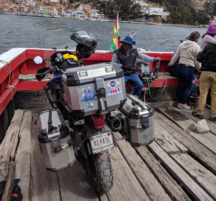
Basic ferry with the captain driving it with an outboard engine.
As I got closer to La Paz, it got colder with snow in the air and then it started to rain pretty heavily. Stupidly, I didn’t put my rain pants on in the belief I would soon be at the hotel. Of course, I got lost and lost my bearings and, honestly, I started to get worried if I would ever find the hotel. The GPS told me to go down a steep dirt road and, eventually, I worked up the courage to do so, the road was wet but I managed to get down into the valley and onto a paved road. After another 45 mins in the pouring rain I did find the hotel! Phew, that was a relief!
Day 46 – July 21 – Mallasa
The hotel called Oberland is a popular place for adventure drivers and riders but now in the middle of winter there are not many here. Today is a miserable day with clouds covering the surrounding mountains and I’m staying at the hotel to keep dry and relax… I was thinking of going into central La Paz to take a tour on the cable car system, which seems like a unique way of transporting people in the city and across to the neighboring city of El Alto. However, with the inclement weather I chose to stay in the hotel.
I talked to the guy who rents Motorcycles and quads. He said the road further south-east might be snow covered and recommended me to stay until there is a sunny day which should clear the roads. I guess I might be here for a few days…

Day 47 – July 22 – La Paz
I took a bus from the hotel to La Paz for a guided tour of the system of connected cable cars. La Paz is built in very mountainous terrain so the city decided to build the cable car system to ferry people around. At the moment there are seven lines with an additional 4 planned.
The high altitude is really affecting me badly. I have not had a good night sleep for days and I’m feeling kind of shitty most of the time so after gong into town tomorrow to get insurance I will start going towards Argentina.

Illimani mountain looks down on La Paz

Llama fetuses. Bizarre custom of putting them in the foundations of new buildings for good luck..

La Paz is the hilliest capitol of any country in the world, as well as the one with the tallest elevation. I’m 10km outside of town at 3200m while El Alto is at 4000m.
Day 48 – July 23 – La Paz to Oruro – 210kms
Went to central La Paz to get insurance for the Mercosur countries which include Bolivia and Argentina and came back to the hotel 1130, packed and got on the bike for Orura. The straight road meant I got to Orura around 1500. The first part involved tackling a steep switch back dirt road that I was worried about but I managed without problems, I did have to stop to let a meeting heavily loaded truck go past but managed to start without stalling. The trick is to keep the revs up, slip the clutch and use the rear brake to control the speed. I can see why a big displacement twin with lots of lowdown torque would be good in such situations – you’re much less likely to stall the engine. Once I cleared the dirt road I got on to Bolivia 1 and after what seemed like a long stretch I finally cleared the areas with markets on both sides of the road, vehicles parked along the entire near side lane and people crossing the road. My fuel was getting low so I stopped at a petrol station to fill up but they were out of gas. This happened for an additional 4 gas-stations and finally when I only had a single bar on the meter I found one that could fill the bike up. I discovered that tourists pay at least twice as much as locals for gas.

The guy filling the gas needed to see an id before filling up the tank. If the id is foreign you pay the foreign price which is around 8 bol while locals pay 3.7 bols.
Day 49 – Oruro to Uyuni – 310kms
I didn’t enjoy Oruro much. It was cold, not much above freezing, and I couldn’t find a restaurant for a long time, in the end I found one on the ninth floor of a hotel and I was the only customer:-( I ordered some pasta dish and it wasn’t too bad, but the wine must have been in an open bottle for months so I drank bottled water – not a very pleasant meal… My hotel, “Houston” (!) was pretty miserable,my room had no windows and it was cold. So I was glad to get out of the town! The road carried on on the alto-plano and was mostly in very good condition.

I had to share the road with llamas.

Snow covered mountains in the background. Beautiful!

Wonderful and strange looking stone shapes along Bolivia road F30.

Arrived in Uyuni about lunch time, this town has a lot of hotels, I guess, for people going to see the salt planes.
What happens to the air pressure in your tires as you go to higher elevations? I checked my tire pressures at sea level and made sure it was the usual 42/36 psi. After riding 1500kms, I checked the pressure again when I arrived Puno and it had now gone up to 45/40 psi – what’s going on? Remember that Puno is at 3800m elevation and 10C colder than when I filled the tires at sea level. First I thought there must be something wrong with the tire gauge and that it only works correctly at sea level. We all know that colder ambient temperature will lower the tire pressure but what does higher elevation do? I couldn’t figure it out so I had to google… It turns out that tire gauges give you the differential pressure between the tire and the ambient pressure and since the ambient pressure is lower as you go higher the difference becomes larger since the internal tire pressure does not change. This means you should not adjust the tire pressure and you should really bring something tabulating what the tire pressure should be as a function of elevation. Interesting.
Day 50 – Uyuni to Tilcara- 480kms
This was going to be a long day including the border crossing to Argentina. After breakfast I loaded my steed up and managed to get out of the severely bumpy parking without incidence and got going on Bolivia 21 which, as I would see was of wildly varying quality. It’s a newly constructed road and most of the way it’s beautiful asphalt but in some places where the construction is still going on it is very rutted gravel. However, in the last 20km before Tupiza it’s the original gravel road and it’s just awful with in some places deep dust and in other places steep ascents and descents. Apparently this was the condition of the entire road up until a few months ago. After Tupiza the road to the boarder was nice and twisty. The boarder crossing was fairly straight forward even though there’s always a bit of confusion. I was lucky in that a young woman with her head screwed on got me the temporary import permit without a single error – unheard of! She told me it was always cold in the border town, hoped that Argentina would be the best country on my trip and wished me luck after inspecting my luggage. Then I set off for Tilcara, a further 220km from the boarder.

Very interesting geology not far from crossing the Argentinian border.
After arriving at the Hostal I booked, I waited around for 10 mins knocking on the door and banging on the gate but no answer. And since data roaming didn’t work I couldn’t reply to the owner’s email… It was getting dark and cold so I decided to look for another place to stay and found a hostel that had a space. I then went walking to find an ATM, the Pesos only comes in 100 nomination bills (which is about 3 usd) so the wallet quickly becomes very fat. Tilcara is kind of an arty, bohemian type place with art galleries and cozy small restaurants. I found one and had a wiener schnitzel with a half bottle of Malbec in freezing cold temperatures, but it was one of the best meals I’ve had on this trip.
Day 51 – Tilcara to San Miguel de Tucuman – 410kms
The hostel I was staying at was a typical back-packer place with people staying up late partying. However, with ear-plugs I was able to get some good sleep… The coffee for breakfast tasted great and then I went to fetch the bike which was parked a block away. When driving in to park I was reluctant because it was a steep incline to the parking space and nowhere to turn the bike around which meant I would need to reverse it down the steep incline. On top of that the driveway was of slate type material so very slippy. Reversing turned out to be challenging in that when I applied the front break the front wheel would slip and since I used both legs to keep the bike up I could not use the rear break but somehow I managed to get it on the streept without incidence. Parking the bike and retrieving the bike has turned out to be, perhaps, the most challenging aspect of handling the bike on the trip. I got shortish legs so that doesn’t help 😉
When starting out it was below freezing so I was afraid that any moisture on the road would have turned to ice so I was very careful before it got a bit warmer. However, the road was good and I made good progress to S.M. Tucuman and arrived not long after lunch.
I have now booked my flight back to Houston and agreed on a drop off date for the bike next week so the trip is nearing it’s end.
Day 52 – July 27 – San Miguel de Tucuman to Cordoba – 560 kms
It was a cold morning and as I came further south the days were getting shorter and today daylight came after 0800. I was on my way by 0830 and took some time getting out of the city and once out in the country side there was a freezing fog. My helmet visor tends to fog up easily when it’s cold which means I have to keep the visor up making it feel even colder. Again, maps.me seemed to be leading me to a minor road and not the major RN9 connecting the two cities. However, after a while, the road quality got better and I could keep a good speed at around 120 km/h. It is, perhaps, the straightest road I’ve been on going for hundreds of kms without a turn. There are always check points along any road where the luggage of the vehicle seems to be checked and I even saw buses where all passengers got off and had their suitcases checked – not sure for what but I suspect drugs. I have been waved through all the check points though, must be my innocent looks or foreign registration that does it. This would be the most kms I’ve done on the trip in one day but I still arrived before 1600. The GPS led me straight to the hotel and the parking was on the ground floor so I rode straight in and parked the bike without problems. I’m now only 750 kms from Buenos Aires.
Day 53 – Cordoba
I needed a break after 5 days and close to 2000 km on the bike and Cordoba was a nice place to spend a day. It’s Argentina’s 2nd largest city and has a nice church so that’s where I went to have a look. They call it the church of the Capuchins and it looks as if they only completed one of the two towers. There’s a big pedestrian area with parks and squares which is always nice in a city.

Capuchin church


Day 54 – Cordoba to Rosario – 400 km
Today I ran out of fuel! The road from Cordoba to Rosario is 400 km and dead straight. However, once out of Cordoba there is no service station until after 200 km – how crazy is that! Luckily I had my reserve fuel tank so no real disaster. Otherwise the ride was kind of boring with huge fields on both sides of the road.
Day 55 – Rosario to Zarate – 210 km
The Rosario hotel was out in a village and no restaurant was open so I had to do without dinner last night. No big deal, though, I did not feel so hungry. The ride today continued on RN9 towards BA on another dead straight dual carriageway road and with the short distance I arrived at noon time and found the hotel quite easily. I walked around town to find an ATM and eventually I found one that worked. The charges for use of ATM are outrageous! The most I could get was 2500 pesos – around USD90 but the charge is 278 pesos, ie. 10%! I’d classify that as robbery! Anyway, after that I had a nice dinner with the best beef of the trip.

Day 56 – Zarate to Ezeiza – 110 km
One of the shortest days of the trip to the town where the B.A. airport is located. When shipping with aircraft you’re only supposed to have minimal fuel in the tank so I had to figure out how much to fill up and I figured 2 liter would be about right. Depending on how fast I go the fuel consumption varies a lot too so it took some figuring out. RN9 goes into BA and then connects to the road that goes to the airport and with RN9 becoming a 6-lane road I managed not to take the right turn to go south and had to do some backtracking to get on the right track again and I eventually got to the hostal.
I was given strict instructions not have any personal effects on the bike for the shipment and I could not ship any camping equipment which meant I had to do a lot of re-packing and I had to wash the reserve tank out well to remove any gasoline smell.
Day 57 – Shipping of the bike
I rode the 9 km to the cargo handling area of the airport where Dakar moto with Javier and Sandra met me and another biker, Manuel. They ship on average two bikes per week so they know what they’re doing and within two hours the export-clearance, “crating” and customs-clearance were completed (compare that to my shipment from Houston!) The crating with clingfilm and flimsy straps to hold the bike in place on the pallet looks a bit dodgy but it seems to work… The bike will go on the direct United Houston flight tomorrow so will arrive Houston before me. The cost is quite a bit cheaper than shipping Houston to Bogota even thought the distance is twice as far. I guess the US is not really set up for exports:-)
BTW. the first thing they did was to weigh the bike and mine came in at 280 kg! And that’s with a near empty tank. I assume that’s pretty accurate but it’s more than I thought.


Day 58 – Buenos Aires
I had a really nice dinner last night in a Spanish restaurant close to the hotel. Wild salmon and some nice Malbec. I slept really well and rested a lot in my room today, I think I deserve to be lazy for a while… Went for a few walks in the city and wow! It’s beautiful! Wide avenues but also large pedestrian areas and big parks with lots of cafes and restaurants.

Beautiful wide avenues with lots of greenery.

Lots of motorcycles! Sign of a great city:-)

Nice looking buildings.

Malvinas war memorial.

Aug 6 – Houston
I arrived back to Houston yesterday but since it was Sunday I could not pick up the bike which actually arrived on Aug 3. So with the help of Uber and a very talkative driver I got to the United Cargo building where the queue was short and I was soon being served and told I needed to pay $60 terminal charge. I asked the lady if I shouldn’t go to customs first to get the bike released and she agreed that I, indeed, needed to do that. After getting the required paperwork I got another Uber to drive me to the customs building which is 6 miles away and we did arrive after first getting lost – the Uber map was incorrect. The customs officer looked at the documents and was back with the approval within a minute, I was very impressed! Now back to United cargo but the Uber app did not let me set the pickup point anywhere apart from the airport terminals so I had to install Lyft and finally a car came to pick me up.
Back at United Cargo I soon had the bike delivered to a place where I could unpack it, mount the screen and make it ready to ride on which took me more than an hour and a bucket of sweat. Riding off the pallet, which is about 7 inches above the floor involved also getting across the metal frame on which the pallet was laid, and I got four people to help in case I screwed it up but I had no problems. Just as I finished it started raining so I waited for a while for it to abate and set off for home.
I read another blog where the blogger described the picking up of the bike from United cargo and he had a really bad experience whereas mine could not have been any better! The whole process only took me 3 hours – great!

Reflections
It dawned on me that I’ve completed my trip! I’m feeling really good about it, but perhaps, hmm – a couple of nice glasses of Malbec helped? So more than 8000 km and some of those pretty slow and arduous kms, especially, in the Andes. It’s been an amazing time and it’s given me a lot of memories. I didn’t really choose to go in the southern hemisphere winter – it was the only time I could go. So is it a good time of the year for such a trip ? Well, if you can stand cold temperatures for most of the trip it’s no problem. I’m not sure if I was particularly lucky – but I’ve had very little rain and I hate rain when I’m riding a motorcycle – it’s way worse than cold, or at least cold when it’s above freezing. So yes, maybe it’s a good time to go, but do bring cold weather gear, I loved my heated pants and jacket and used them more than I thought I would – and heated grips is definitively a must.
What about other drivers on the road? Peru and Bolivia, be prepared for pretty aggressive driving, particularly the mini buses, after they stop to let passengers on or off, it seems they will pull out on the road without even looking if there’s anyone coming, they expect other drivers to slow down… The same when overtaking, they will flash their lights expecting oncoming traffic to give them space. Ecuador and Colombia – they are not as aggressive as drivers in Peru or Bolivia. The best drivers are without a doubt the ones in Argentina, on several occasions I noted their courteousness; In Cordoba I came out of the hotel carpark and the GPS hadn’t figured out where I was going to turn and I was in the rightmost lane at a traffic light when the GPS told me to turn left so I turned the indicators on and as the light turned green the cars in the two left two lanes waited patiently for me to turn left – no horns or anything else indicating they were impatient for me to go. And in San Miguel de Tucumen a driver moved his car over so I could go past him while waiting at a red light. I’m really impressed with the Argentinian drivers,they must have very good driver’s education or it’s part of their general behavior?
I would definitively recommend a bike with tires suitable for dirt roads. Wide low profile tires, such as fitted to touring or sport bikes would not be good. There are so many stretches of bad road and so many speed bumps with incredibly aggressive profiles as well as the roads in towns in Peru and Bolivia being incredibly bad with deep rain gutters running across the road as well as deep ruts making low profile tires a bad choice.
My Triumph Tiger 800 worked flawlessly throughout the trip. I had absolutely no problems and the only work I did was to adjust the chain once. I had mounted a Scott-oiler so the chain was well lubricated throughout the trip. I mounted Shinko 705 tires and they lasted throughout the trip and gave good grip on asphalt as well as dirt roads. If I had gone much further the rear tire would have needed to be changed but the front tire have lots of life left.
Perhaps a lot of riders are keen to go on a similar trip but always find reasons not to? And I’m certainly one of those, but I felt that if I didn’t do it now – I would never do it… I’m definitively not saying that my trip was something incredibly special, there are so many others that are doing much more arduous and longer trips, and, in fact, I’ve met several on this trip, however, it’s still quite an undertaking and requires some support from your family and loved ones. I was very lucky in that my missus supported me from the beginning and along the way, thank you my darling!
Some beautiful music by one of my favorite artists…
July 14, 2018 at 04:59
So many beautiful photos! It’s so great of you sharing your experiences and the gorgeous views; both the landscape, the small towns and their inhabitants, local animals u.s.w.!
July 14, 2018 at 05:37
Thanks dearest sister!
July 17, 2018 at 04:32
I wonder, when you leave your bike for several days, do you lock it in a safe garage or how do you do for not having to worry about it getting stolen or vandalised?
July 17, 2018 at 06:41
When I left it in Quito it was parked in the “German” hostel for a small fee. Otherwise it’s only been overnight and hostels or hotels have always had access to parking behind locked doors.
July 19, 2018 at 04:24
Macho Picho – really amazing!
July 19, 2018 at 06:59
Yes, it’s been voted one of the new seven wonders of the world…
July 24, 2018 at 07:39
More fun and games! Great stuff you’re sharing!
July 24, 2018 at 19:20
Thanks Bruce! Some days are more exciting than others!
July 25, 2018 at 09:10
Carl do not worry about the short brake lever. I have a short one also on my Tiger. I just tell people that I do not need to use my ‘pinky’ to stop. I also found that on the left side the gear shift being a little bent makes more room for size 12 boots. Tigers are top heavy and hard to catch once they start to lean. I am glad it did not fall on you or damage more stuff. So as they say ” keep the shine on up and the rubber down”. We really enjoy your words and pictures and the videos a lot
July 28, 2018 at 08:05
Hi John, I don’t worry about the short brake lever either, I use my two middle fingers for braking. The crash bars I put on saved the day and avoided damage to any of the plastics or the panniers.
July 25, 2018 at 13:15
Actually, Carl, you need to adjust your tire pressures when your altitude change enough to affect ambient pressure by more than 2-3 psi. You set the tire pressure based on what the tire pressure gauge reads in the morning with the tires cold. The GAUGE PRESSURE is exactly what the pressure inside the tire is exerting all around the tire. This force (or springiness) is what allows the tire sidewalls to bear the load of your motorcycle. Imagine if you travel to a place where the ambient pressure is so high that the gauge pressure reads 0 psi. Your tire will go flat and unable to suspend any load. Conversely, if the ambient pressure is so low, that the gauge pressure exceeds the maximum pressure rating of your tires, you risk tire failure from over pressure.
July 25, 2018 at 13:20
Whenever I travel to NM or CO, I always bring a little portable air compressor with me. When I climb altitude, I let air out. Coming back to the low plains, I pump them back up.
July 30, 2018 at 10:57
Ok. I don’t want to argue, it’s not clear in my mind what’s correct. It seems the pressure inside the tire is created by the air being contained by the tire walls and you do not want to change that because the ambient pressure is lower…
August 10, 2018 at 14:59
If you let go of a helium-filled balloon into the sky, eventually it will burst because the air pressure outside continues to drop as the balloon rises. The pressure inside the balloon doesn’t change, but the differential pressure vs. ambient becomes greater and greater – to a point where the balloon pops. Your tires experience the same effect.
August 10, 2018 at 15:06
Here is an article that should help clarify:
http://denverexpresscare.com/high-altitude-and-your-tire-pressure
July 25, 2018 at 13:39
So nice hearing your voice in the video from day 48!
July 25, 2018 at 18:20
Hey Anna! I record my voice on most videos while recording but then substitute with music to make it bearable…
July 28, 2018 at 18:29
What hero! 4000m high and still keeping on. You deserve a medal ????
July 29, 2018 at 12:40
Thanks Jeremy! The elevation didn’t bother me much while riding. Only when trying to get to sleep the brain kept racing making it near impossible to nod off. Not sure what the mechanism is but I guess the heart keeps on pumping to cover for the loss of oxygen and more of it goes to the brain?
July 30, 2018 at 06:29
????
August 2, 2018 at 02:48
Thank you so very much dearest brother for sharing your thoughts and experiences from the road trip through South America! I’m very impressed of your braveness!
August 2, 2018 at 05:01
Thanks Anna!
August 2, 2018 at 12:37
Hi Carl, great RR. See you back in Houston. Thank you for sharing .
Emmanuel
August 4, 2018 at 16:47
Dear Carl,
was great to meet you in Bogota! Even with the problems of the transport of your bike you always kept positiv – not so usual!
I followed your tour and was glad to read you are fine and enjoying, even with some difficulties.
Congrats for your adventure and all the best for your future.
Hope to stay in contact.
Anton
August 5, 2018 at 12:10
Hi Toni, thanks for your kind words! I really enjoyed meeting you too and your input into my trip route was invaluable. I would probably have gone from Ecuador to the Peruvian coast rather than the inland route you suggested through Cajamarka which became one of the highlights of the trip. Yes, let’s stay in contact!
August 28, 2018 at 12:20
What a trip and experience! Thanks for sharing it with us. Look forward to seeing you on a future “local” ride!